Donation Request 2024
You do not have to be logged in to donate.
DONATE
Members and Supporters, the MountainViews Committee requests your help to meet the costs of the website and of other activities such as insured events or publications.You do not have to be logged in to donate.
Welcome to MountainViews
If you want to use the website often please enrol (quick and free) at top right.
If you want to use the website often please enrol (quick and free) at top right.
Overview

For more map options click on any overview map area or any detail map feature.
Detail Map Features
Find Suggested Walks
Find hill, mountain, island, coastal feature.
Videos
Recent Contributions
 Get Notifications
Get Notifications
Cunnigar: Short trek to summit
 Fergalh
Westtown Hill: Tramore's Highest Point
 DeirdreM
Lobawn Loop - Clockwise avoids any steep ascent! Easy stream crossing.
Knockbrinnea West Top: Eflanagan on the Knockbrinneas
 eflanaga
Knockbrinnea West Top: Larger Twin
 Collaborative entry
Walk on tracks above Glendalough
 ceadeile
Ascending the Knockbrinneas from the north.
 simon3
Knockaunanattin West Top: Views, loughs and a navigational aid.
 simon3
Circumnavigation of Tawny Rower
 glencree
Knockaunanattin West Top: First step to Stumpa Duloigh
 Collaborative entry
Knockaunanattin West Top: Impressive defile start leads to airy ridgeline.
 Peter Walker
Near Church Mountain, Wicklow (Ireland)
Conditions and Info
Use of MountainViews is governed by conditions and a privacy policy.
Read general information about the site.
Opinions in material here are not necessarily endorsed by MountainViews.
Hillwalking is a risk sport. Information in comments, walks, shared GPS tracks or about starting places may not be accurate for example as regards safety or access permission. You are responsible for your safety and your permission to walk.
See the credits and list definitions.
 Visit our Facebook page.
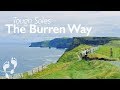
Video display
West Clare
Area Cen: Ennistymon Hills Subarea
Place count in area: 14,
OSI/LPS Maps: 51, 52, 57, 58
Highest place: Slievecallan, 391m
Maximum height for area: 391 metres,
Maximum prominence for area: 365 metres,
Places in area West Clare:
Cen: Ennistymon Hills:Clifden Hill 189mKnocknalarabana 204m
NE: Burren East:Abbey Hill 240mBouleevin 222mKnockanes 205mMullagh More 180mSlievecarran 326m
NW: Burren West:Aillwee 304mGleninagh Mountain 316.1mSlieve Elva 344m
S: Ennis Hills:Ben Dash 267mCloontohil 190mSlieveacurry 255mSlievecallan 391m
Note: this list of places includes island features such as summits, but not islands as such.
Highest place:
Slievecallan, 391mPlaces in area West Clare:
Cen: Ennistymon Hills:
Clifden Hill 189mKnocknalarabana 204mNE: Burren East:
Abbey Hill 240mBouleevin 222mKnockanes 205mMullagh More 180mSlievecarran 326mNW: Burren West:
Aillwee 304mGleninagh Mountain 316.1mSlieve Elva 344mS: Ennis Hills:
Ben Dash 267mCloontohil 190mSlieveacurry 255mSlievecallan 391mNote: this list of places includes island features such as summits, but not islands as such.

Bedrock type: Sandstone, siltstone & mudstone, (Central Clare Group)
Knocknalarabana is the 1395th highest place in Ireland. Knocknalarabana is the most westerly summit in the West Clare area.
Linkback: https://mountainviews.ie/summit/1288/
COMMENTS for Knocknalarabana 1 of 1  Follow this place's comments

|
|
|
|
||
| MountainViews.ie, a Hill-walking Website for the island of Ireland. 2400 Summiteers, 1480 Contributors, maintainer of lists: Arderins, Vandeleur-Lynams, Highest Hundred, County Highpoints etc | |||