Members and Supporters, the MountainViews Committee requests your help to meet the costs of the website and of other activities such as insured events or publications.
Feature count in area: 64, by county: Derry: 34, Tyrone: 39, of which 9 are in both Derry and Tyrone,
OSI/LPS Maps: 12, 13, 6, 7, 8
Highest Place: Sawel 678m
Starting Places (21) in area Sperrin Mountains: Altinure Road, Banagher Glen Nature Reserve, Barnes Gap Car Park, Crocknakin, Drumnaspar Picnic CP, Glenchiel Road, Glenedra Bridge, Glenelly Road, Parkreagh, Goles Road, Lough Ouske, Moneyneany Village, Moydamlaght Forest, Moydamlaght Road, Mullaghmore, Mullaghbane, Spaltindoagh, Sperrin Hamlet, Sperrin Heritage Centre, Sperrin Heritage Centre W, Sperrin Road, Barnes Top, Sperrin Road, Glashagh Bridge, Sperrin Road, Sperrin
Summits & other features in area Sperrin Mountains: E: Magherafelt Hills: Slieve Gallion NE Top 493.6m E: Magherafelt Hills: Slieve Gallion 526.6m N: Claudy Hills: Crockdooish 321m, Curradrolan Hill 270m, Eglish 277m, Letterlogher 249m, Mullaghmeash Hill 244m, Slieveboy 259m, Straid Hill 303m NE Cen: Glenelly North East: Barnes Top 456m, Craigagh Hill 460m, Crockbrack 526.1m, Knockanbane Mountain 441m, Meenard Mountain 620m, Meenard Mtn W Top 480m, Mullaghaneany 627m, Mullaghash 480m, Mullaghsallagh 485m, Oughtmore 569m, Spelhoagh 568m NE: Glenshane North: Benbradagh 465m, Boviel Top 454m, Carn Hill 448m, Carntogher 464m, Moneyoran Hill 414m NE: Glenshane South: Bohilbreaga 478m, Coolnasillagh Mountain 423m, Corick Mountain 430m, Crockalougha 407m, Mullaghmore 550m, White Mountain 537m NW Cen: Glenelly North West: Dart Mountain 619m, Dart Mountain North-West Top 525m, Learmount Mountain 489m, Learmount Mountain South Top 492m, Mullaghasturrakeen 581m, Mullaghcarbatagh 517m, Mullaghclogha 635m, Mullaghclogher 572m, Mullaghdoo 568m, Sawel 678m NW: Maheramason Hills: Clondermot Hill 220m, Gortmonly Hill 218m, Slievekirk 370m SE Cen: Glenelly South East: Carnanelly 562m, Carnanelly West Top 503.4m, Mullaghbane 467m, Mullaghturk 416m SE: Cookstown Hills: Cregganconroe 300m, Fir Mountain 362m, Oughtmore 382m SW Cen: Glenelly South West: Clogherny Top 408m, Craignamaddy 385m, Crocknamoghil 335m, Mullaghbolig 442m, Spaltindoagh 420m SW: Mullaghcarn: Curraghchosaly Mountain 416m, Mullaghcarn 542m, Mullaghcarn South Top 525m SW: Newtownstewart Hills: Bessy Bell 420m, Mullaghcroy 242m W: Strabane: Balix Hill 403m, Knockavoe 296m, Owenreagh Hill 400m
Note: this list of places may include island features such as summits, but not
islands as such.
Gortmonly Hill, 218mHill
Place Rating ..
, Tyrone County in Ulster province, in Binnion Lists, Gortmonly Hill is the 1365th highest place in Ireland.
Grid Reference C39639 07923,
OS 1:50k mapsheet 7 Place visited by: 24members, recently by: trostanite, Claybird007, dregishjake, dregish, LorraineG60, MichaelG55, m0jla, eamonoc, Fergalh, eejaymm, sandman, jimmyread, Aidy, chalky, FilHil
I visited this place: NO (You need to be a logged-in member for this.)
Longitude: -7.382662, Latitude: 54.917355, Easting: 239639, Northing: 407923,
Prominence: 170m, Isolation: 5.6km ITM: 639579 907910 Bedrock type: Psammite & semipellite, (Claudy Formation) Notes on name: Gortmonly is a townland in Donaghedy parish. Gortmonly Hill is also known as Dullerton Mountain or Sollus, names derived from other townlands on its slopes. No Irish name is now known for it, but it is possible that the one or both of the names Dowletter mountayne and Mullaghnegerry, which occur in the Civil Survey of ca. 1655, refer to this hill. Furthermore, Bready, the village at the western foot of the hill near the banks of the Foyle is probably named from this hill since bréadach consistently means ‘high ground’ (not ‘fragments’ or ‘broken ground’). It is derived from the Celtic root brigant- meaning ‘high’ and can be compared with the Continental Celtic names Brigantio (modern Briançon in France), Brigantium (Bregenz in Austria), and with Brent, which occurs as the name of several English rivers. The sound changes involved are * brigant- (Proto-Celtic) > *brent- (early Brittonic?) > bréad- (Irish), with adjectival suffix -ach added.
Short or GPS IDs, 6 char: Grt218, 10 char: GrtmnlyHil Linkback: https://mountainviews.ie/summit/1027/
From the minor road to Craigtown follow the substantial cement track at A (C400 075) uphill (locked gate where it meets the road). As the track climbs up hill it turns left and starts to level off and you pass the summit on your right, before shortly coming to a couple of gates. The summit area is all fields, there is no open ground here at all, so observe the countryside code and go through the gate on your right and walk the short distance to the summit & return the same way. There was livestock in all the fields here, so make sure you close any gates you open.
There is a small area where you can park just off the minor road, NNE from its junction with the cement track, just passed a house on your left on the way to Craigtown. Linkback: mountainviews.ie/summit/1027/comment/4036/
Read Less
Read More
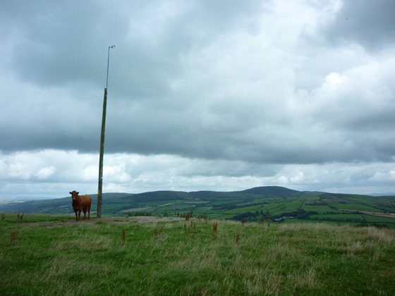
Picture: Guardian of Gortmonly Hill, Slievekirk in background
Climb it if you must!
by Harry Goodman
19 Aug 2010
I climbed this hill on Wed 11 Aug 2010 by the same access track as that identified by three5four0 parking at, but not blocking the entrance B (C40035 07522). I followed the cement path steeply up hill and when it turned sharply to the left continued on up to the crest where cement changed to gravel. At this point I turned right, crossed the fence and walked out the short distance to the hill top marked by a high wooden pole C (C39650 07921). Just beside the pole was a large flat concrete area probably once a base for a farm shelterbut now long gone.The pole in my view is as good a point to mark the top as any other part of the flat top to this hill. However a quick stomp around for anyone so inclined will ensure crossing the highest point! The top can be reached up and down in 30 minutes. Just NW of the top a little lower down is a group of large boulders which may have some ancient origin. From the top, for a little variety, I dropped down the field along the fence line to a gate before crossing over and re-joining the cement path back down to the start. Gortmonly Hill, Slievekirk and Clondermot Hill can all be climbed in a morning or afternoon with only short driving distances between. For links see my comments on each of the other hills. Linkback: mountainviews.ie/summit/1027/comment/6033/
Read Less
Read More
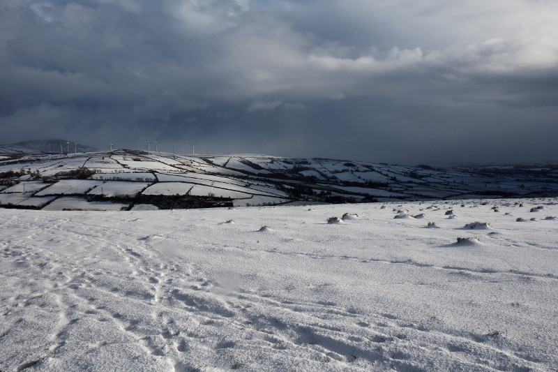
Picture: Slievekirk Under Stormy Skies
Electrifying Experience
by Aidy
29 Jan 2015
Having already been up Curraghchosaly, I planned to do a few more smaller hills in West Tyrone and Derry, starting here. Walked up the concrete road described in the other comments, in snow, hail and strong winds. There was a shooting party, after woodcock, on the side of the hill, but they assured me I would neither be interfering with their pursuits, nor be in danger of being shot! Great views at the top towards Slievekirk, and down over the Foyle. Just as I was about to leave, a really bad storm came in, with horizontal hail and vicious wind. it got incredibly dark, but suddenly everything lit up blue with a flash of lightning and a simultaneous thunderclap. The strike must have been very close, and in such an exposed spot, I was very lucky. I wouldn't have thought it was possible to get down an ice and snow covered concrete road so quickly, but it turns out it is! I also decided that was enough hills for one day. Linkback: mountainviews.ie/summit/1027/comment/17821/
Use of MountainViews is governed by conditions and a privacy policy.
Read general information about the site. Opinions in material here are not necessarily endorsed by MountainViews.
Hillwalking is a risk sport. Information in comments, walks, shared GPS tracks or about starting places may
not be accurate for example as regards safety or access permission. You are responsible for your safety and your permission to walk.
See the credits and list definitions.


 Our Facebook page.