Donation Request 2024

DONATE
Members and Supporters, the MountainViews Committee requests your help to meet the costs of the website and of other activities such as insured events or publications.
You do not have to be logged in to donate.
Features
Nearby features appear when you click the map.
Declutter tracks on map.
Place Search
Video
X
Pub: by
Dartry Mountains Area , NE: Arroo Keeloges Subarea
Feature count in area: 31, by county: Leitrim: 22, Sligo: 10, of which 1 is in both Sligo and Leitrim, OSI/LPS Maps: 16, 17, 25, 26
Highest Place: Truskmore 647m

Starting Places (22) in area Dartry Mountains:
Aghavoghil Middle, Arroo Trail CP, Ballaghnatrillick, Ballintrillick Forest, Barrs East, Castletown, Crumpaun, Curraghan Road, Dough Mountain NW, Dough Mountain West, Drumcliff River Road, Eagles Rock, Edenbaun, Glencar Waterfall, Gleniff Horseshoe Road, Lough Cloonaquin North, Luke's Bridge, Mountain Wood, Poulveha River, Thur East, Tormore Car Park, Truskmore Transmitter Entrance

Summits & other features in area Dartry Mountains:
N: Truskmore: Gortnagarn 445m, Tievebaun 611m, Truskmore 647m, Truskmore SE Cairn 631m
NE: Arroo Keeloges: Aganny Top 482m, Aghalateeve 432m, Agow Top 423m, Arroo Mountain 523m, Conwal North 421m, Crocknagapple 372m, Keeloges 452m
NW: Benbulbin: Annacoona Top 597m, Benbulbin 526m, Benwiskin 514m, Benwiskin South Top 508m, Kings Mountain 462m
SE: Manorhamilton Hills: Ballaghnabehy Top 413m, Benbo 415m, Dough Mountain 462m, Lackagh Mountain 449m, Larkfield 305m, Naweeloge Top 441m, Thur Mountain 442m
SW: Castlegal Hills: Copes Mountain 452m, Crockauns 463m, Hangmans Hill 400m, Keelogyboy Mountain 438m, Keelogyboy Mountain Far East Top 418m, Keelogyboy Mountain NE Top 435m, Keelogyboy Mountain SW Top 417m, Leean Mountain 417m

Note: this list of places may include island features such as summits, but not islands as such.
Rating graphic.
Arroo Mountain, 523m Mountain Sliabh Aradh A name in Irish,
Place Rating ..
Ir. Sliabh Áradh [logainm.ie], 'ladder-mountain’ or ‘mountain of
the slope’
, Leitrim County in Connacht province, in Arderin Lists, Arroo Mountain is the 499th highest place in Ireland. Arroo Mountain is the most northerly summit in the Dartry Mountains area.
Grid Reference G83303 52070, OS 1:50k mapsheet 16
Place visited by: 102 members, recently by: Lucky1, Overarroo, csd, farmerjoe, abeach, conormcbandon, AlanReid, TommyV, markwallace, Hyperstorm, Jimmy600leavey, srr45, wintersmick, annem, TommyMc
I visited this place: NO (You need to be a logged-in member for this.)
Longitude: -8.25801, Latitude: 54.416977, Easting: 183303, Northing: 352070, Prominence: 436m,  Isolation: 2.8km, Has trig pillar
ITM: 583253 852075
Bedrock type: Dark fine-grained cherty limestone, (Dartry Limestone Formation)
Notes on name: Arroo is a townland in Rossinver parish, barony of Rosclogher. The name may be derived from Ir. áradh, ‘ladder’. Alternatively, it may be related to Welsh arro, ‘bank’. Either way, the name seems to refer to the steep slopes of Arroo Mountain which rise from the shore of Lough Melvin.
  Short or GPS IDs, 6 char: ArMntn, 10 char: ArMntn

Linkback: https://mountainviews.ie/summit/407/
Gallery for Arroo Mountain (Sliabh Aradh) and surrounds
Summary for Arroo Mountain (Sliabh Aradh): Excellent views, access difficulty from the west.
Summary created by simon3, Harry Goodman 2022-04-27 11:33:25
            MountainViews.ie picture about Arroo Mountain (<em>Sliabh Aradh</em>)
Picture: Summit cairn on Arroo Mt. above Lough Melvin
Start from the east at Avoghil Mid (G858 516). Alternately there is another clear parking space 300m or so south up the road. Follow the distinct track across the road from the parking spot, which continues for about 500m, and then peters out amid a turf-cutting area. Continue directly west across gently rising and in parts, distinctly boggy land and then across steeper land to the top.
Start from the west at around A (G805 525). This route known as the Arroo Trail is NOT recommended at present because a landowner has withdrawn permission.
There are fine views NE over L. Melvin and N to the Bluestacks. To the W is Truskmore, the highest of the Dartry Mountains, and further around S to the Castlegal ridge.
Linkback: mountainviews.ie/summit/407/comment/5166/
Member Comments for Arroo Mountain (Sliabh Aradh)
Comment create / edit display placeholder

            MountainViews.ie picture about Arroo Mountain (<em>Sliabh Aradh</em>)
Picture: http://www.youtube.com/user/CapVertigo#p/a/u/3/kojN2hcB_a4
A Short Film
by CaptainVertigo 13 Nov 2011
Since no one can be a judge in their own case I will say nothing about my short film on Arroo - other than than it irritates me greatly. Nevertheless I must concede that one might consider a quick look before heading up. Delighted to see that Harry Goodman has written up the route.

http://www.youtube.com/user/CapVertigo#p/a/u/3/kojN2hcB_a4 Linkback: mountainviews.ie/summit/407/comment/6626/
Read Less
Read More

            MountainViews.ie picture about Arroo Mountain (<em>Sliabh Aradh</em>)
Picture: Bilbo's neighbourhood?
Arroo from the east
by Colin Murphy 11 Feb 2013
Most walkers approach Arroo from the steeply-sided west slope, but as I wanted to also take in Conwal North top to the east, I decided to start from the eastern slopes. There is a parking space opposite a track, just where some forestry starts at Avoghil Mid (G858 516). (Alternately there is another clear parking space 300m or so south up the road). Follow the distinct track across the road from the parking spot, which continues for about 500m, and then peters out amid a turf-cutting area. Continue directly west across gently rising and in parts, distinctly boggy land (although it is relatively easy to navigate around the very marshy bits). Around B (G848 516) the grassy ground starts to rise fairly steeply, but is very firm underfoot. The slope eases about 300m later and there is a relatively gentle climb all the way to the summit, the approach offering a partial view of the towering cliffs on Arroo's north side. There is also a fascinating area to the north-east below the summit, (see pic) featuring a number of diminutive but very sharp peaks, surrounded by grassy bumps and knolls, which looks like the kind of place you might find a hobbit living! Returned the way I'd come, getting back to the car precisely 2 hours later. Linkback: mountainviews.ie/summit/407/comment/14917/
Read Less
Read More

            MountainViews.ie picture about Arroo Mountain (<em>Sliabh Aradh</em>)
simon3 on Arroo Mountain
by simon3 20 Mar 2003
A long ridge extends South East from the highest point on Arroo to Lough Aganny. This picture was taken from near Lough Aganny, looking towards the cliffs of Largy, part of a broad spur that leads to the right of the picture to Truskmore. Largy itself is not so interesting apart from its cliffs, however centrally on the skyline can be seen Crockauns (463m) and to the left edge the start of the rise to Hangmans Hill and Keelogyboy Mountain (438m). As written up by Claude Wall, these are part of the Castlegal Mountains. "The Castlegal Mountains, south of Glencar, are somewhat neglected owing to the proximity of the Dartry range, but they provide a good ridge walk ... "
The Lough that is visible is Glenade Lough. This view will be familar to anyone who has done the "Benbulben Challenge" as the route from Arroo goes near Lough Aganny, passes to the right of Glenade Lough, turns left diagonally upwards towards the end of the cliffs and then right again along the top of the cliffs. Linkback: mountainviews.ie/summit/407/comment/388/
Read Less
Read More

            MountainViews.ie picture about Arroo Mountain (<em>Sliabh Aradh</em>)
Picture: Arroo's North-West aspect
eflanaga on Arroo Mountain
by eflanaga 21 Apr 2006
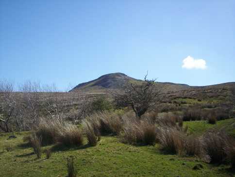
Started this walk at a track in the townland of Aghanlish C (G80481 52522) (95m). Parking is a problem as the road is very narrow. I went to the bungalow on the other side of the hedge to seek permission to park. However, there was no one home. A woman in the neighbouring house was quick to spot me and to investigate what I was doing there. When I explained that I was looking for permission to park she directed me to the first house on the left about 500m further down the road, which belonged to a family member of the people who owned the bungalow. The gentleman at the house was very obliging and allowed me to park in the drive of the bungalow. I pulled in well to the side so as not to cause any obstruction. The track runs from the road for about 500m before reaching a gate at the side of an outbuilding and then continues for about another 100 metres or so before it peters out naturally into the lower end of a Burn. From here I took a bearing of 116 degrees SW. I kept to the left bank of the Burn until I was able to cross above it to a fence D (G82290 51925) (347m). Once over the fence I continued on the same bearing veering to the right of the main bulk of the mountain so as to reach the lower end of an obvious ridge. At the top of the ridge I turned left towards the mountain climbing a narrow spine, the top of which 
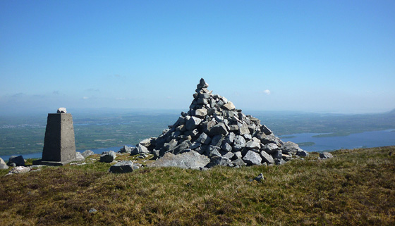
E (G82755 51852) (495m), adjoins an eroded area of peat and shingle just below the top of the plateau. I took a bearing of 56 degrees NE from here, which is about 500m from the summit cairn. However, if you veer left to the end the eroded area there is a fairly well worn track which swings across to the other side of the plateau and from there all the way to the summit marked by a Trig point & cairn. GPS reading here was 
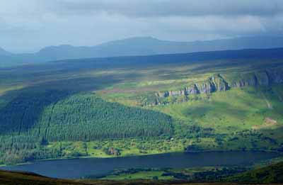
F (G83303 52060) with a height of 522m. The views from the summit are spectacular. To the west Tievebaun & Truskmore looked resplendent as they basked in the sunshine. Across Donegal Bay Slieve League was clearly visible. Below and to the east the impressive Lough Melvin and beyond that to the north-east Lough Erne. Due south the hills of County Leitrim were bathed in wonderful sunshine. The walk (I returned by same route) took 2 and a half hours and was one of the most pleasant I have enjoyed in recent times. On way back to car I noticed some fresh blood on the track and shortly after a sheep with an obvious limp and in some distress. On arriving at the car the gentleman who owned the bungalow was home and I informed him about the animal. He in turn informed his brother-in-law who owned the sheep. Linkback: mountainviews.ie/summit/407/comment/2291/
Read Less
Read More

            MountainViews.ie picture about Arroo Mountain (<em>Sliabh Aradh</em>)
simon3 on Arroo Mountain
by simon3 20 Mar 2003
This picture shows the steep cliffs to the North and East of the summit of Arroo. According to Duchas, the Irish Heritage service, the steep cliffs and rocks beneath them contain many botanical rarities, including various forms of Saxifrage, Mountain Avens and Mountain Sorrel. Linkback: mountainviews.ie/summit/407/comment/389/
Read Less
Read More
EDIT Point of Interest
text
Videos

Recent Contributions
x
Conditions and Info
Use of MountainViews is governed by conditions and a privacy policy.
Read general information about the site.
Opinions in material here are not necessarily endorsed by MountainViews.
Hillwalking is a risk sport. Information in comments, walks, shared GPS tracks or about starting places may not be accurate for example as regards safety or access permission. You are responsible for your safety and your permission to walk.
See the credits and list definitions.

OSi logo
OSNI/LPS logo
Open Street Map
(Various variations used.)
British summit data courtesy:
Database of British & Irish Hills