Donation Request 2024

DONATE
Members and Supporters, the MountainViews Committee requests your help to meet the costs of the website and of other activities such as insured events or publications.
You do not have to be logged in to donate.
Features
Nearby features appear when you click the map.
Declutter tracks on map.
Place Search
Video
X
Pub: by
Wicklow Area , NW: Blessington Subarea
Feature count in area: 115, by county: Wicklow: 108, Kildare: 4, Wexford: 2, Carlow: 3, of which 1 is in both Wexford and Wicklow, of which 1 is in both Carlow and Wicklow, OSI/LPS Maps: 28B, 55, 56, 61, 62, AWW, EW-DM, EW-LG, EW-WE, EW-WS
Highest Place: Lugnaquilla 924.7m

Starting Places (205) in area Wicklow:
1916 Memorial Car Park, Aghavannagh Ow Bridge, Aghowle Wood, Altidore Wood Entrance, Annacurra National School, Annalecka Bridge, Asbawn Brook L8350, Aughrim National School, Ballard Road, Ballinabarny Gap, Ballinagappoge Bridge Layby, Ballinagappoge Mountain Hairpin, Ballinagore, Ballinahinch Wood, Ballinastoe MBT CP, Ballinastraw South, Ballineddan Upr Fork, Ballinfoyle Upr Cross, Ballycoog, Ballycreen Brook Bridge, Ballycumber, Ballycumber Bridge, Ballycumber Lane, Ballycumber Wicklow Way, Ballylerane, Ballylow Bridge, Ballylusk Quarry, Ballymanus Lane, Ballymoyle Shooting Lodge, Ballynultagh Gap, Ballynultagh Lane, Ballyreagh Wood, Ballyross Forest, Ballysmuttan Long Stone, Baravore, Barnbawn South, Barranisky North, Barranisky West, Bohilla Land Roundabout, Bohilla Lane Mid, Boranaraltry Bridge, Bray Harbour, Brewel West, Brittas Bay North CP, Buckroney Sand Dunes CP, Bus Terminus, Camera Hill Track Cross, Castletimon Wood North, Clara Vale, Clone House Road, Clonegal, Cloon Wood Cp, Coate Bridge, Coolballintaggart Ledge, Coolbawn House Lane, Cransillagh Brook , Crone Wood CP, Crossbridge, Crossoona Rath, Cummer Wood South, Curtlestown Wood CP, Deputy's Pass CP, Derralossary Church, Derry River Bridge, Devil's Glen CP, Devil's Glen Wood, Djouce Wood Calary, Djouce Wood Lake, Djouce Wood Long Hill, Donard, Donnelly's Lane Car Sales, Drumgoff Forest, Dunranhill North, Dunranhill SE, Dunranhill South, Dwyer McAllister Cottage CP, Enniskerry, Fentons Pub, Fitzsimons Park GAA, unuseableFlemings Footbridge Glen Rd, Gap Pub, Gap Road, Glen Beach CP, Glen of the Downs CP, Glenbride Lane, Glenbride Lodge, Glencree Reconciliation, Glendalough, Glenealy GAA, Glenmacnass Tonelagee CP, Glenmalure Hostel, Glenmalure Lodge, Glenmalure Waterfall, Glenview Hotel, Gowle House, Great Sugar Loaf CP, Grove Bar, Heffernans Well Wood, Hill View, Hollywood Glen, JB Malone CP, Johnnie Fox Pub, Keadeen NE trail, Keadeen Trailhead, Kevins Way Footbridge, Kilbride Army Camp Entrance, Kilcandra South, Kilcommon View, Killalongford Wood, Kilmacrea Cross Roads, Kilranelagh House Gate, Kilruddery Car Park, Kilruddery Cottages, Kings River, Kippure Bridge, Kippure Estate, Kippure Transmitter Gate, Knickeen Cross, Knocknaboley Lane Leeraghs Bog, Knocknaboley Lane Stone Cottage, Knockrath Little, Knockree west, Kyle Loop North, Lackan Wood S, Lake Dr Fraughan Brook, Lake Drive, Lake Park Cross, Lake View Pub, Laragh Free Car Park, Laragh NSch, Lead Mines CP, Liffey Bridge, Liffey Head Bridge, Lough Bray Lower, Lough Bray Upper, Lough Tay North Viewing Point, Lough Tay Wicklow Way CP, Luglass Lane L97561, Lugnagun Track, Macreddin Village, Mangans Lane, Military Road Carrigshouk Hill, Military Road Inchavore River Nth, Military Road Inchavore River Sth, Military Road NW Lough Tay, Military Road Ballyboy Bridge, Military Road Cloghoge Brook, Military Road Croaghanmoira, Military Road Fananierin, Military Road LaraghWicklow Way, Military Road Slieve Maan, Monspolien Bridge, Moortown House, Mountain Rescue HQ, Muskeagh Little Wood, Nahanagan Lough NE, Novara Avenue, Bray, Oiltiagh Brook Knickeen, Old Bridge Cross, Old Bridge Scouts , Old Wicklow Way entrance, Paddock Hill SE, Pier Gates CP, Powerscourt Waterfall CP, Putland Road, Quintagh East, Raheen Park CP, Raheenleagh East, Railway Walk CP, Rathdrum Railway Station, Rednagh Wood, Rocky Valley, Roundwood, Sally Gap, Sally Gap N, Seefin Trailhead, Seskin SE, Shankill Tributary Bridge, Shay Elliott, Sheepshanks Bridge, Shillelagh, Slievecorragh Track, Slievefoore South, Sraghoe Brook, St John's Church, St Kevins Chair, St Kevins Church, St Kevins Way R756, Stone Circle Bridge, Stookeen South, Stranahely Wood, Stranakelly Cross Roads, Tallyho, Templeboden, Tithewer, Tomcoyle L, Tomriland Wood, Toor Brook, Trooperstown Hill Access, Turlough Hill CP, Upper Lake CP, Vallymount GAA CP, Vartry Reservoir Upper, Zellers Pub

Summits & other features in area Wicklow:
Cen: Glendalough North: Brockagh Mountain 556.9m, Brockagh Mountain NW Top 549.5m, Brockagh Mountain SE Top 471.7m, Camaderry East Top 677.3m, Camaderry Mountain 698.6m, Conavalla 734m, Tomaneena 682.4m
Cen: Glendalough South: Carriglineen Mountain 456.6m, Cullentragh Mountain 510m, Derrybawn Mountain 476.1m, Kirikee Mountain 474.5m, Lugduff 653.2m, Lugduff SE Top 638m, Mullacor 660.7m, Trooperstown Hill 430m
N Cen: Tonelagee: Carrignagunneen 561m, Fair Mountain 571.2m, Stoney Top 713.7m, Tonelagee 815.8m, Tonelagee E Top 668m, Tonelagee South-East Top 545.8m
NE: Bray & Kilmacanogue: Bray Head Hill 238.9m, Carrigoona Commons East 242m, Downs Hill 372.9m, Great Sugar Loaf 501.2m, Little Sugar Loaf 342.4m
NE: Djouce: Djouce 725.5m, Knockree 342.1m, Maulin 570m, Tonduff 642m, Tonduff East Top 593m, War Hill 684.8m, White Hill 631.1m
NE: Fancy: Ballinafunshoge 480m, Kanturk 527.4m, Knocknacloghoge 532.4m, Luggala 593.3m, Robber's Pass Hill 508.9m, Scarr 640m, Scarr North-West Top 559.8m, Sleamaine 430m
NE: Vartry: Ballinacorbeg 336m, Ballycurry 301m, Dunranhill 342m, Mount Kennedy 365.9m
NW: Blessington: Carrigleitrim 408m, Lugnagun 446.2m, Slieveroe 332m, Sorrel Hill 599.5m
NW: Mullaghcleevaun: Black Hill 602.2m, Carrigshouk 572.5m, Carrigvore 682.4m, Duff Hill 720.8m, Gravale 719m, Moanbane 703m, Mullaghcleevaun 846.7m, Mullaghcleevaun East Top 796m, Silsean 698m
S: Aughrim Hills: Cushbawn 400m, Killeagh 249m, Moneyteige North 427m, Preban Hill 389m
S: Croaghanmoira: Ballinacor Mountain 529.3m, Ballycurragh Hill 536m, Ballyteige 447m, Carrickashane Mountain 508m, Croaghanmoira 662.3m, Croaghanmoira North Top 579.5m, Fananierin 426m, Slieve Maan 547.8m, Slieve Maan North Top 546.1m
S: Croghan Kinsella: Annagh Hill 454m, Croghan Kinsella 606m, Croghan Kinsella East Top 562.1m, Slievefoore 414m
S: Shillelagh Hills: Lakeen 357m, Monaughrim 206m, Seskin 344m, Stookeen 420m
S: Tinahely Hills: Ballycumber Hill 429.7m, Eagle Hill 296m, Muskeagh Hill 398.2m
SE: Wicklow South East: Ballinastraw 284m, Ballyguile Hill 188m, Barranisky 280m, Carrick Mountain 381m, Collon Hill 238m, Kilnamanagh Hill 217m, Westaston Hill 270m
W: Baltinglass: Ballyhook Hill 288m, Baltinglass Hill 382m, Carrig Mountain 571m, Carrigeen Hill 298m, Cloghnagaune 385m, Corballis Hill 258m, Keadeen Mountain 653m, Spinans Hill 409m, Spinans Hill SE Top 400m, Tinoran Hill 312m
W: Cen Lugnaquilla: Ballineddan Mountain 652.3m, Benleagh 689m, Camenabologue 758m, Camenabologue SE Top 663m, Cloghernagh 800m, Corrigasleggaun 794.6m, Lugnaquilla 924.7m, Slievemaan 759.7m
W: Donard: Brewel Hill 222m, Church Mountain 544m, Corriebracks 531m, Lobawn 636m, Slievecorragh 418m, Sugarloaf 552m, Table Mountain 701.7m, Table Mountain West Top 563m

Note: this list of places may include island features such as summits, but not islands as such.
Rating graphic.
Sorrel Hill, 599.5m Mountain
Place Rating ..
, Wicklow County in Leinster province, in Arderin Lists, Sorrel Hill is the 291st highest place in Ireland.
Grid Reference O04221 11887, OS 1:50k mapsheet 56
Place visited by: 473 members, recently by: KateLeckie, Tommer504, MeabhTiernan, rogers, Carolineswalsh, muddypaws, Sonyalaw, Nailer1967, MickM45, Arcticaurora, Kaszmirek78, lauracardiff, trampisob, miriam, Kirsty
I visited this place: NO (You need to be a logged-in member for this.)
Longitude: -6.443084, Latitude: 53.147589, Easting: 304222, Northing: 211888, Prominence: 154.5m,  Isolation: 2.2km
ITM: 704147 711918
Bedrock type: Granite with microcline phenocrysts, (Type 2p microcline porphyritic)

  Short or GPS IDs, 6 char: SrlHl, 10 char: Sorel Hil

Linkback: https://mountainviews.ie/summit/280/
Gallery for Sorrel Hill and surrounds
Summary for Sorrel Hill : An easy walk
Summary created by simon3, march-fixer, Dessie1, wicklore 2013-06-23 21:25:12
            MountainViews.ie picture about Sorrel Hill
Picture: Sorrel Hill Northwest Face
Sorrel Hill is easily approached along the well defined track starting at the small car park at BNulta Gp (O04387 10862). The road leading up to the car park can be somewhat potholed on the higher section. Another word of caution – Ballysmuttan Bridge at A (O05650 14812) has been closed for a lengthy period of time. (October 2010).(You will be glad to know that there is a shiny new bridge erected over the Liffey now!) This is a common route to the Black Hill/Sorrel Hill car park, and it is an awkward and lengthy detour to the car park if you first arrive at the closed bridge. Better to approach from Blessington/Lacken to the west along the N81.

It is just over 1km to the top of Sorrel Hill with an ascent of about 150 metres. The main track to the summit is muddy at times. [See track-1596 which uses an alternative and less boggy route that lies slightly to the east]. As you climb views emerge of the Blessington Lakes to the west, and the plains beyond. The bulk of the Mullaghcleevaun group of hills is directly to the south, while the Seefin – Seahan circuit of hills is to the north. Kippure holds court off to the east.

An alternative route to Sorrel Hill is from Ballynatona to the north. There's space to park a car at the entrance to the forest track at B (O055 138), which you can follow to within several hundred metres of the summit.

The summit of Sorrel Hill has a megalithic cairn. It is an easy walk, especially for children or beginners.
Linkback: mountainviews.ie/summit/280/comment/5040/
Member Comments for Sorrel Hill
Comment create / edit display placeholder

cloud and wind.
by hillwalkerliam 9 Jun 2010
I put a rock on the cairn. i fell around 3 times. the walk was cool. sweets are energy.the cloud was touching the ground. it went for a few seconds and then came back again. this was my sixth mountain and i am six. Linkback: mountainviews.ie/summit/280/comment/5864/
Read Less
Read More

            MountainViews.ie picture about Sorrel Hill
Picture: Sorrel Hill as viewed from Lugnagun, with Kippure to the west
darrenf on Sorrel Hill
by darrenf 18 Mar 2010
There is ample carparking available at BNulta Gp (O045 108). From here one can clearly see the track snaking up toward black hill. Fine views over Blessington and the reservoir are available. Directly behind you there is another clear track leading up toward Sorrel hill which will take you directly to the summit. Once on the summit you will note the huge cairn which marks the top.

From the car to the summit of Sorrel Hill is just over 1.1km and could be reached within 20mins. An easy bag by any accounts. To extend the walk a little I decided to head for Lugnagun. Refer to same for rest of route. Linkback: mountainviews.ie/summit/280/comment/4519/
Read Less
Read More

            MountainViews.ie picture about Sorrel Hill
Picture: No sorrel in sight
padodes on Sorrel Hill
by padodes 3 Feb 2009
In Irish, I have seen this hill referred to as ‘Cor tSamhaidh’, the Round Hill of the Sorrel. The sorrel in question is obviously the plant of that name, called ‘samhadh’ in Irish (‘Rumex acetosa’ in botany). It is the long-leaved common sorrel that often ends up in our salads. One would therefore expect an abundance of the plant here, if it did give its name to the hill, yet I have so far never found a specimen. Then again, I have never gone out avidly looking for one, either.

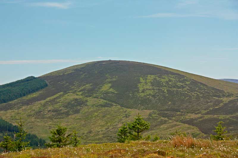
Leaving this botanical conundrum aside, the most notable feature on Sorrel is the megalithic cairn on its summit, which has a diameter of about 20m. (Enterprising modern hands have added a further small cairn to the original beneath.) In the photo, just to the left of the mound, can be seen in the distance the cluster of Seefin, Seefingan and Seahan, equally crowned with megaliths. These hills lie between 6 and 8kms away, across the valley of the Liffey.

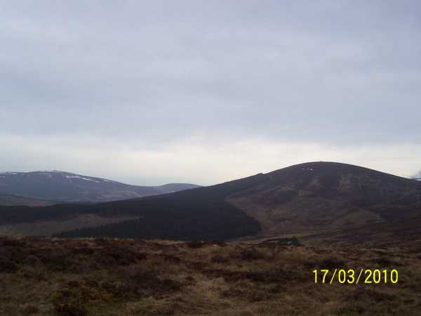
There are other remnants of the past in the immediate vicinity, too, though they are difficult to find. On the broad saddle between Sorrel and Lugnagun there are, reportedly, traces of several Stone Age enclosures (detectable in aerial photography) and another cairn about 10m in diameter, but I have looked for them in vain in this very broken terrain. A little further on, inside the forest fence, there is a small megalithic tomb (marked, this time, on the OSI map), but now so hemmed in by forest that it is in danger of being totally engulfed (Coillte protecting our heritage!).

One thing our megalithic forebears did not see from the top of Sorrel is, of course, the 11 kilometre long Pollaphuca Reservoir to the west. Although we know today that there was, in fact, a lake there between 15,000 and 10,000 years ago, fed by meltwater from a glacier, it had long disappeared before the builders of the megaliths ever came upon the scene. The dam that forms the present lake, dating from 1940, has given us a view of the past that makes even Stone Age man a recent blow-in by comparison. Linkback: mountainviews.ie/summit/280/comment/3561/
Read Less
Read More

            MountainViews.ie picture about Sorrel Hill
Picture: Cairn on summit of Sorrel Hill
sharkey on Sorrel Hill
by sharkey 4 Jul 2009
Took a wee walk up Sorrel Hill a few weeks ago. Nice little walk, not too tough and lovely views + the Cairn on top always makes it worth while. Just nice to connect with that energy that seems to eminate from these old stones. Had a fleeting glimpse of a small herd of deer as I neared the summit too which was nice. Linkback: mountainviews.ie/summit/280/comment/3903/
Read Less
Read More

            MountainViews.ie picture about Sorrel Hill
Picture: Where am I going!
Misty sorrel.
by Dessie1 23 Jun 2013
Climbed Sorrel hill starting from carpark at BNulta Gp (O04387 10862).40 min round trip.Weather was closing in so scrambled up the very wet and boggy slope to the summit in a hurry.Note:Ballysmuttan bridge is now reopened.The cairn is an impressive sight for such a small hill. Linkback: mountainviews.ie/summit/280/comment/6249/
Read Less
Read More
EDIT Point of Interest
text
Videos


Recent Contributions
x
Conditions and Info
Use of MountainViews is governed by conditions and a privacy policy.
Read general information about the site.
Opinions in material here are not necessarily endorsed by MountainViews.
Hillwalking is a risk sport. Information in comments, walks, shared GPS tracks or about starting places may not be accurate for example as regards safety or access permission. You are responsible for your safety and your permission to walk.
See the credits and list definitions.

OSi logo
OSNI/LPS logo
Open Street Map
(Various variations used.)
British summit data courtesy:
Database of British & Irish Hills