Donation Request 2024

DONATE
Members and Supporters, the MountainViews Committee requests your help to meet the costs of the website and of other activities such as insured events or publications.
You do not have to be logged in to donate.
Features
Nearby features appear when you click the map.
Declutter tracks on map.
Place Search
Video
X
Pub: by
Wicklow Area , NW: Mullaghcleevaun Subarea
Feature count in area: 115, by county: Wicklow: 108, Kildare: 4, Wexford: 2, Carlow: 3, of which 1 is in both Wexford and Wicklow, of which 1 is in both Carlow and Wicklow, OSI/LPS Maps: 28B, 55, 56, 61, 62, AWW, EW-DM, EW-LG, EW-WE, EW-WS
Highest Place: Lugnaquilla 924.7m

Starting Places (205) in area Wicklow:
1916 Memorial Car Park, Aghavannagh Ow Bridge, Aghowle Wood, Altidore Wood Entrance, Annacurra National School, Annalecka Bridge, Asbawn Brook L8350, Aughrim National School, Ballard Road, Ballinabarny Gap, Ballinagappoge Bridge Layby, Ballinagappoge Mountain Hairpin, Ballinagore, Ballinahinch Wood, Ballinastoe MBT CP, Ballinastraw South, Ballineddan Upr Fork, Ballinfoyle Upr Cross, Ballycoog, Ballycreen Brook Bridge, Ballycumber, Ballycumber Bridge, Ballycumber Lane, Ballycumber Wicklow Way, Ballylerane, Ballylow Bridge, Ballylusk Quarry, Ballymanus Lane, Ballymoyle Shooting Lodge, Ballynultagh Gap, Ballynultagh Lane, Ballyreagh Wood, Ballyross Forest, Ballysmuttan Long Stone, Baravore, Barnbawn South, Barranisky North, Barranisky West, Bohilla Land Roundabout, Bohilla Lane Mid, Boranaraltry Bridge, Bray Harbour, Brewel West, Brittas Bay North CP, Buckroney Sand Dunes CP, Bus Terminus, Camera Hill Track Cross, Castletimon Wood North, Clara Vale, Clone House Road, Clonegal, Cloon Wood Cp, Coate Bridge, Coolballintaggart Ledge, Coolbawn House Lane, Cransillagh Brook , Crone Wood CP, Crossbridge, Crossoona Rath, Cummer Wood South, Curtlestown Wood CP, Deputy's Pass CP, Derralossary Church, Derry River Bridge, Devil's Glen CP, Devil's Glen Wood, Djouce Wood Calary, Djouce Wood Lake, Djouce Wood Long Hill, Donard, Donnelly's Lane Car Sales, Drumgoff Forest, Dunranhill North, Dunranhill SE, Dunranhill South, Dwyer McAllister Cottage CP, Enniskerry, Fentons Pub, Fitzsimons Park GAA, unuseableFlemings Footbridge Glen Rd, Gap Pub, Gap Road, Glen Beach CP, Glen of the Downs CP, Glenbride Lane, Glenbride Lodge, Glencree Reconciliation, Glendalough, Glenealy GAA, Glenmacnass Tonelagee CP, Glenmalure Hostel, Glenmalure Lodge, Glenmalure Waterfall, Glenview Hotel, Gowle House, Great Sugar Loaf CP, Grove Bar, Heffernans Well Wood, Hill View, Hollywood Glen, JB Malone CP, Johnnie Fox Pub, Keadeen NE trail, Keadeen Trailhead, Kevins Way Footbridge, Kilbride Army Camp Entrance, Kilcandra South, Kilcommon View, Killalongford Wood, Kilmacrea Cross Roads, Kilranelagh House Gate, Kilruddery Car Park, Kilruddery Cottages, Kings River, Kippure Bridge, Kippure Estate, Kippure Transmitter Gate, Knickeen Cross, Knocknaboley Lane Leeraghs Bog, Knocknaboley Lane Stone Cottage, Knockrath Little, Knockree west, Kyle Loop North, Lackan Wood S, Lake Dr Fraughan Brook, Lake Drive, Lake Park Cross, Lake View Pub, Laragh Free Car Park, Laragh NSch, Lead Mines CP, Liffey Bridge, Liffey Head Bridge, Lough Bray Lower, Lough Bray Upper, Lough Tay North Viewing Point, Lough Tay Wicklow Way CP, Luglass Lane L97561, Lugnagun Track, Macreddin Village, Mangans Lane, Military Road Carrigshouk Hill, Military Road Inchavore River Nth, Military Road Inchavore River Sth, Military Road NW Lough Tay, Military Road Ballyboy Bridge, Military Road Cloghoge Brook, Military Road Croaghanmoira, Military Road Fananierin, Military Road LaraghWicklow Way, Military Road Slieve Maan, Monspolien Bridge, Moortown House, Mountain Rescue HQ, Muskeagh Little Wood, Nahanagan Lough NE, Novara Avenue, Bray, Oiltiagh Brook Knickeen, Old Bridge Cross, Old Bridge Scouts , Old Wicklow Way entrance, Paddock Hill SE, Pier Gates CP, Powerscourt Waterfall CP, Putland Road, Quintagh East, Raheen Park CP, Raheenleagh East, Railway Walk CP, Rathdrum Railway Station, Rednagh Wood, Rocky Valley, Roundwood, Sally Gap, Sally Gap N, Seefin Trailhead, Seskin SE, Shankill Tributary Bridge, Shay Elliott, Sheepshanks Bridge, Shillelagh, Slievecorragh Track, Slievefoore South, Sraghoe Brook, St John's Church, St Kevins Chair, St Kevins Church, St Kevins Way R756, Stone Circle Bridge, Stookeen South, Stranahely Wood, Stranakelly Cross Roads, Tallyho, Templeboden, Tithewer, Tomcoyle L, Tomriland Wood, Toor Brook, Trooperstown Hill Access, Turlough Hill CP, Upper Lake CP, Vallymount GAA CP, Vartry Reservoir Upper, Zellers Pub

Summits & other features in area Wicklow:
Cen: Glendalough North: Brockagh Mountain 556.9m, Brockagh Mountain NW Top 549.5m, Brockagh Mountain SE Top 471.7m, Camaderry East Top 677.3m, Camaderry Mountain 698.6m, Conavalla 734m, Tomaneena 682.4m
Cen: Glendalough South: Carriglineen Mountain 456.6m, Cullentragh Mountain 510m, Derrybawn Mountain 476.1m, Kirikee Mountain 474.5m, Lugduff 653.2m, Lugduff SE Top 638m, Mullacor 660.7m, Trooperstown Hill 430m
N Cen: Tonelagee: Carrignagunneen 561m, Fair Mountain 571.2m, Stoney Top 713.7m, Tonelagee 815.8m, Tonelagee E Top 668m, Tonelagee South-East Top 545.8m
NE: Bray & Kilmacanogue: Bray Head Hill 238.9m, Carrigoona Commons East 242m, Downs Hill 372.9m, Great Sugar Loaf 501.2m, Little Sugar Loaf 342.4m
NE: Djouce: Djouce 725.5m, Knockree 342.1m, Maulin 570m, Tonduff 642m, Tonduff East Top 593m, War Hill 684.8m, White Hill 631.1m
NE: Fancy: Ballinafunshoge 480m, Kanturk 527.4m, Knocknacloghoge 532.4m, Luggala 593.3m, Robber's Pass Hill 508.9m, Scarr 640m, Scarr North-West Top 559.8m, Sleamaine 430m
NE: Vartry: Ballinacorbeg 336m, Ballycurry 301m, Dunranhill 342m, Mount Kennedy 365.9m
NW: Blessington: Carrigleitrim 408m, Lugnagun 446.2m, Slieveroe 332m, Sorrel Hill 599.5m
NW: Mullaghcleevaun: Black Hill 602.2m, Carrigshouk 572.5m, Carrigvore 682.4m, Duff Hill 720.8m, Gravale 719m, Moanbane 703m, Mullaghcleevaun 846.7m, Mullaghcleevaun East Top 796m, Silsean 698m
S: Aughrim Hills: Cushbawn 400m, Killeagh 249m, Moneyteige North 427m, Preban Hill 389m
S: Croaghanmoira: Ballinacor Mountain 529.3m, Ballycurragh Hill 536m, Ballyteige 447m, Carrickashane Mountain 508m, Croaghanmoira 662.3m, Croaghanmoira North Top 579.5m, Fananierin 426m, Slieve Maan 547.8m, Slieve Maan North Top 546.1m
S: Croghan Kinsella: Annagh Hill 454m, Croghan Kinsella 606m, Croghan Kinsella East Top 562.1m, Slievefoore 414m
S: Shillelagh Hills: Lakeen 357m, Monaughrim 206m, Seskin 344m, Stookeen 420m
S: Tinahely Hills: Ballycumber Hill 429.7m, Eagle Hill 296m, Muskeagh Hill 398.2m
SE: Wicklow South East: Ballinastraw 284m, Ballyguile Hill 188m, Barranisky 280m, Carrick Mountain 381m, Collon Hill 238m, Kilnamanagh Hill 217m, Westaston Hill 270m
W: Baltinglass: Ballyhook Hill 288m, Baltinglass Hill 382m, Carrig Mountain 571m, Carrigeen Hill 298m, Cloghnagaune 385m, Corballis Hill 258m, Keadeen Mountain 653m, Spinans Hill 409m, Spinans Hill SE Top 400m, Tinoran Hill 312m
W: Cen Lugnaquilla: Ballineddan Mountain 652.3m, Benleagh 689m, Camenabologue 758m, Camenabologue SE Top 663m, Cloghernagh 800m, Corrigasleggaun 794.6m, Lugnaquilla 924.7m, Slievemaan 759.7m
W: Donard: Brewel Hill 222m, Church Mountain 544m, Corriebracks 531m, Lobawn 636m, Slievecorragh 418m, Sugarloaf 552m, Table Mountain 701.7m, Table Mountain West Top 563m

Note: this list of places may include island features such as summits, but not islands as such.
Rating graphic.
Carrigvore, 682.4m Mountain An Charraig Mhór A name in Irish,
Place Rating ..
(Ir. An Charraig Mhór [PNCW*], 'the big rock'), Corrigvore, Wicklow County in Leinster province, in Arderin, Vandeleur-Lynam Lists, Carrigvore is the 138th highest place in Ireland.
Grid Reference O12269 10136, OS 1:50k mapsheet 56
Place visited by: 511 members, recently by: rhw, MeabhTiernan, orlaithfitz, maoris, davidrenshaw, Prem, Carolineswalsh, Nailer1967, knightsonhikes, SeanPurcell, ToughSoles, muddypaws, Magic, Kaszmirek78, CaminoPat
I visited this place: NO (You need to be a logged-in member for this.)
Longitude: -6.323476, Latitude: 53.130231, Easting: 312269, Northing: 210137, Prominence: 70.7m,  Isolation: 1.9km
ITM: 712193 710168
Bedrock type: Granite with microcline phenocrysts, (Type 2p microcline porphyritic)

  Short or GPS IDs, 6 char: Crgvr, 10 char: Carrigvore

Linkback: https://mountainviews.ie/summit/133/
Gallery for Carrigvore (An Charraig Mhór) and surrounds
Summary for Carrigvore (An Charraig Mhór): High boggy ridge SW of the Sally Gap.
Summary created by simon3, march-fixer, Dessie1 2013-05-27 08:32:43
            MountainViews.ie picture about Carrigvore (<em>An Charraig Mhór</em>)
Picture: Carrigvore from the SE
The Sally Gap crossroads SalGp (O13015 10996) at the intersection of R115 and R759 is an ideal start point for a short trip up Carrigvore.The summit can be reached by taking a 223 deg true heading from the crossroad all the way to top,roughly 1.1 km. A large granite laden summit awaits with fine 360 deg views.A great point to start a good circuit of hills with Gravale, Duff Hill, Mullagcleevaun East Top and Mullaghcleevaun within reach.
Another starting point, particularly if you are doing the a longer circuit is to start at the Kippure Centre at around KipureEst (O085 141).

The large rock outcrop at the summit provides a lovely viewing point and even has a water font carved into the top of the highest rock - not sure about the quality of the water though! Would be a magnificent sheltered spot of a sunny day.
Linkback: mountainviews.ie/summit/133/comment/4893/
Member Comments for Carrigvore (An Charraig Mhór)
Comment create / edit display placeholder

            MountainViews.ie picture about Carrigvore (<em>An Charraig Mhór</em>)
padodes on Carrigvore
by padodes 23 Sep 2008
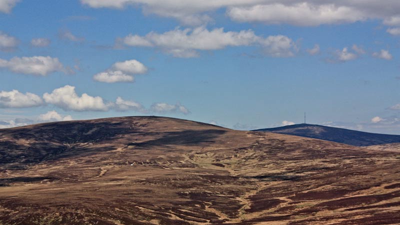
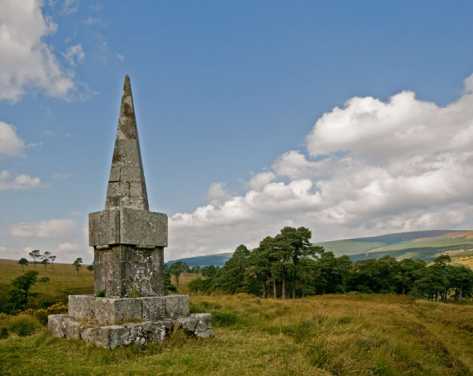
Carrigvore stretches out a slender finger northwest into the Liffey Valley. At its tip, it touches the unique area of Coronation Plantation. From what I gather, this was one of the first plantations in Ireland and goes back to the 1830s, when the landowner, the Marquis of Downshire, decided to have trees planted here for the betterment of his estate. It takes its name from the coronation of William IV in 1831. You will come upon a rather unexpected obelisk at A (O0958 1290) (see photo), which commemorates this project of afforestation. The weathered inscription is partly illegible at present, but I have seen one historian describe it as saying: “Coronation Plantation, Lordship of Blessington, County of Wicklow. This plantation in the Brocky Mountains of 500 Irish (acres) laid out by the Most Honourable the Marquis of Downshire”. From what I have been able to decipher myself, however, the cramped wording on the stone would run somewhat differently.

The trees in the plantation, some of which are visible in the photo, are stately Scots pine in open groves, with here and there an intermingling of oak. Since the average life of a Scots pine is 350 years, those in Coronation Plantation are now into the second half of their natural cycle. Although they have grown well in Wicklow’s acidic soil, it appears they haven’t been able to propagate as they would in their Highland home, and so are doomed to disappear.

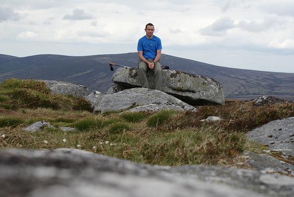
This whole area, I think, is often missed by walkers who are intent on getting to the top of nearby Carrigvore, Gravale or Kippure, but there’s a lot of enjoyment to be had here, too, wandering aimlessly over the wavy moor-grass from grove to grove, on the lookout for red squirrel, or following a fringe of trees downstream, along the tumbling course of a youthful Liffey. It’s an enjoyment that, a handful of generations hence, will have ceased to be. Linkback: mountainviews.ie/summit/133/comment/3334/
Read Less
Read More

            MountainViews.ie picture about Carrigvore (<em>An Charraig Mhór</em>)
Picture: Carrigvore
I'll be back!!
by Dessie1 19 Jul 2010
Climbed Carrigvore on the 28-5-10 on a very changeable evening.Took the straight forward route from Sally's Gap (R115/R759 road) at the crossroads travelling SW direction all the way to the top (1.1 Km). Ground was good underfoot almost "carpet like" in places and an easy 25min trip up to summit. Started for Gravale to the SW but due to a sudden change in weather from sunshine to very threatening dark cloud decided to call it a day and made for a return to base before the rain gear was tested! A lot of care was required on the descent as the Mountain had a few hidden gems in the form of large holes hidden nicely on the slope which would gladly have swallowed my leg up to the waist!.Will go for the full Carrigvore,Gravale,Duff and Mull circuit on my return next time as the view from Carrigvore teased a nice trip. Linkback: mountainviews.ie/summit/133/comment/5959/
Read Less
Read More

            MountainViews.ie picture about Carrigvore (<em>An Charraig Mhór</em>)
Rocky top
by padodes 27 May 2013
The cheerless winter sunshine behind the granite tor that gives its name to Carrigvore (Carraig Mhór) may not look very inviting, but the tingling, icy conditions of the last few weeks have created some of the best walking conditions I can remember along the ridge that extends from here, by way of Gravale and Duff Hill, to Mullacleevaun East. The hard hand of Jack Frost has even turned the notorious peaty trenches around Gravale into dazzling crusty avenues of access. The problem with this walk is, of course, its linearity. Unless you can arrange another car at the end, there is little alternative but to retrace your steps to Carrigvore. The possibility of dropping down to the roughly parallel Military Road, as suggested in another comment, is a brave attempt at circularity, but I’m not sure it is one that appeals very greatly to weary feet shod in stiff mountain boots.

Starting from the parking area (and occasional dump) at TayNW (O1376 0876), just south of the Sally gap, it is exactly 2 kms as the crow flies, and almost as the walker walks, to the summit of Carrigvore. . Linkback: mountainviews.ie/summit/133/comment/3516/
Read Less
Read More

            MountainViews.ie picture about Carrigvore (<em>An Charraig Mhór</em>)
csd on Carrigvore
by csd 23 Mar 2003
Carrigvore is a quick trot up from the Sally Gap. You're helped enormously by the fact that the road is already about 500 m above sea level, so the 682 m peak is easily attained. The slog up is pretty uninteresting, but the summit itself has an interesting rock formation and a deep pool (see below). This picture shows the summit with Gravale in the distance. Linkback: mountainviews.ie/summit/133/comment/390/
Read Less
Read More

sinbadw on Carrigvore
by sinbadw 2 Dec 2005
We started from the car-park off the Military road at grid Ref TayNW (O13720 08800) and angled straight for the top of the hill. The circa 2 km distance took longer than expected (approx 40 Mins) due to a combination of a bracing gale in our teeth and numerous peat trenches . Once we had established that the rock formation and the pool were still there we turned towards Gravale and set off. The overall route we took can be seen in my additional posting. Linkback: mountainviews.ie/summit/133/comment/1425/
Read Less
Read More
EDIT Point of Interest
text
Videos


Recent Contributions
x
Conditions and Info
Use of MountainViews is governed by conditions and a privacy policy.
Read general information about the site.
Opinions in material here are not necessarily endorsed by MountainViews.
Hillwalking is a risk sport. Information in comments, walks, shared GPS tracks or about starting places may not be accurate for example as regards safety or access permission. You are responsible for your safety and your permission to walk.
See the credits and list definitions.

OSi logo
OSNI/LPS logo
Open Street Map
(Various variations used.)
British summit data courtesy:
Database of British & Irish Hills