Donation Request 2024
You do not have to be logged in to donate.
DONATE
Members and Supporters, the MountainViews Committee requests your help to meet the costs of the website and of other activities such as insured events or publications.You do not have to be logged in to donate.
Welcome to MountainViews
If you want to use the website often please enrol (quick and free) at top right.
If you want to use the website often please enrol (quick and free) at top right.
Overview

For more map options click on any overview map area or any detail map feature.
Detail Map Features
Find Suggested Walks
Find hill, mountain, island, coastal feature.
Videos

Recent Contributions
 Get Notifications
Get Notifications
Westtown Hill: Tramore's Highest Point
 DeirdreM
Lobawn Loop - Clockwise avoids any steep ascent! Easy stream crossing.
Knockbrinnea West Top: Eflanagan on the Knockbrinneas
 eflanaga
Cunnigar: Short trek to summit
 Fergalh
Knockbrinnea West Top: Larger Twin
 Collaborative entry
Walk on tracks above Glendalough
 ceadeile
Knockaunanattin West Top: Views, loughs and a navigational aid.
 simon3
Circumnavigation of Tawny Rower
 glencree
Knockaunanattin West Top: First step to Stumpa Duloigh
 Collaborative entry
Ascending the Knockbrinneas from the north.
 simon3
Knockaunanattin West Top: Impressive defile start leads to airy ridgeline.
 Peter Walker
Near Church Mountain, Wicklow (Ireland)
Conditions and Info
Use of MountainViews is governed by conditions and a privacy policy.
Read general information about the site.
Opinions in material here are not necessarily endorsed by MountainViews.
Hillwalking is a risk sport. Information in comments, walks, shared GPS tracks or about starting places may not be accurate for example as regards safety or access permission. You are responsible for your safety and your permission to walk.
See the credits and list definitions.
 Visit our Facebook page.
Video display
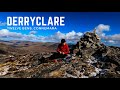
Twelve Bens
Area SE: Glencoaghan Loop Subarea
Place count in area: 34,
OSI/LPS Maps: 37, 44, EW-CON, MSW
Highest place: Benbaun, 729m
Maximum height for area: 729 metres,
Maximum prominence for area: 684 metres,
Places in area Twelve Bens:
Cen: Lough Auna Hills:Cregg 297mTownaloughra East Top 216m
Cen: Polladirk:Bencullagh 632mMaumonght SW Top 454mDiamond Hill 442mKnockbrack 442mMaumonght 602m
E: Glencorbet:Benbaun 729mBenbrack 582mBenbaun 477mKnockpasheemore 412mBenfree 638mMuckanaght 654m
N: Doughruagh:Altnagaighera 549mBenchoona 581mBenchoona East Top 585mCurrywongaun 273mDoughruagh 526mDoughruagh South Top 525mGarraun 598mGarraun South Top 556mLetterettrin 333m
SE: Glencoaghan Loop:Bencollaghduff 696mBenglenisky 516mBenlettery 577mBencorr 711mBencorr North Top 690mBencorrbeg 577mBinn an tSaighdiúra 653mBenbreen 691mBenbreen Central Top 680mBenbreen North Top 674mDerryclare 677mBengower 664m
Note: this list of places includes island features such as summits, but not islands as such.
Highest place:
Benbaun, 729mPlaces in area Twelve Bens:
Cen: Lough Auna Hills:
Cregg 297mTownaloughra East Top 216mCen: Polladirk:
Bencullagh 632mMaumonght SW Top 454mDiamond Hill 442mKnockbrack 442mMaumonght 602mE: Glencorbet:
Benbaun 729mBenbrack 582mBenbaun 477mKnockpasheemore 412mBenfree 638mMuckanaght 654mN: Doughruagh:
Altnagaighera 549mBenchoona 581mBenchoona East Top 585mCurrywongaun 273mDoughruagh 526mDoughruagh South Top 525mGarraun 598mGarraun South Top 556mLetterettrin 333mSE: Glencoaghan Loop:
Bencollaghduff 696mBenglenisky 516mBenlettery 577mBencorr 711mBencorr North Top 690mBencorrbeg 577mBinn an tSaighdiúra 653mBenbreen 691mBenbreen Central Top 680mBenbreen North Top 674mDerryclare 677mBengower 664mNote: this list of places includes island features such as summits, but not islands as such.

Bedrock type: Pale quartzites, grits, graphitic top, (Bennabeola Quartzite Formation)
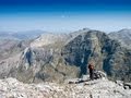
This peak is particularly impressive when viewed across the abyss of Mám na Gaoithe from Bengower. Braon can mean 'drip' or 'drop', but may be a personal name here. It is the basis of the surnames Ó Braoin and Mac Braoin, anglicised as Breen and McBreen. Binn Bhraoin is the 126th highest place in Ireland.
Linkback: https://mountainviews.ie/summit/122/
COMMENTS for Benbreen (Binn Bhraoin) 1 2 Next page >>  Follow this place's comments

|
|
|
|
||
| MountainViews.ie, a Hill-walking Website for the island of Ireland. 2400 Summiteers, 1480 Contributors, maintainer of lists: Arderins, Vandeleur-Lynams, Highest Hundred, County Highpoints etc | |||