Donation Request 2024
You do not have to be logged in to donate.
DONATE
Members and Supporters, the MountainViews Committee requests your help to meet the costs of the website and of other activities such as insured events or publications.You do not have to be logged in to donate.
Welcome to MountainViews
If you want to use the website often please enrol (quick and free) at top right.
If you want to use the website often please enrol (quick and free) at top right.
| General | Whatever you want to say that doesn't fit under the comments about places or another forum. |
1 2 3 4 5 .. 409 Next page >>
| Post details | Post (Contract pics) | ||
| murphysw 2024-02-26 15:20:24 |
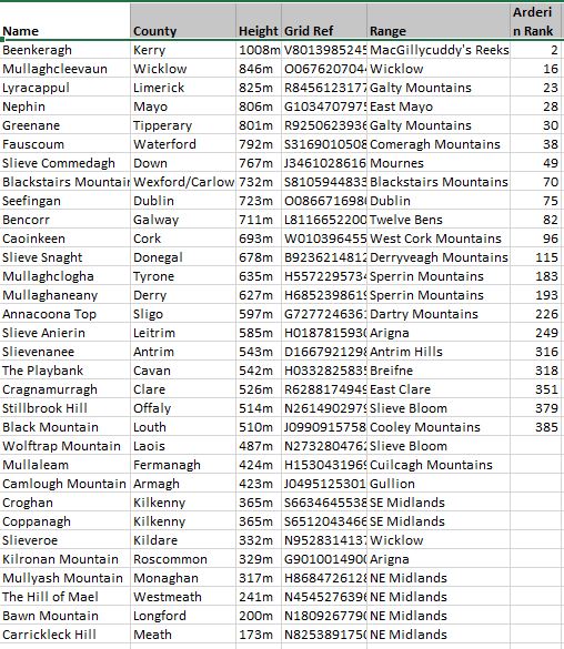
Ireland's County Second Summits
I got an email recently from Miriam Kennedy as a result of completing the County Highpoints list. I didn't complete the survey in time, but it has got me thinking. The Seven Second Summits is considered a harder challenge than the Seven Summits, so I wondered what an Irish County version would be like. I couldn't find a listing anywhere, so I put together the attached list myself. Let me know if I've gotten any of them wrong! |
||
| mcrtchly 2024-02-25 18:52:24 |
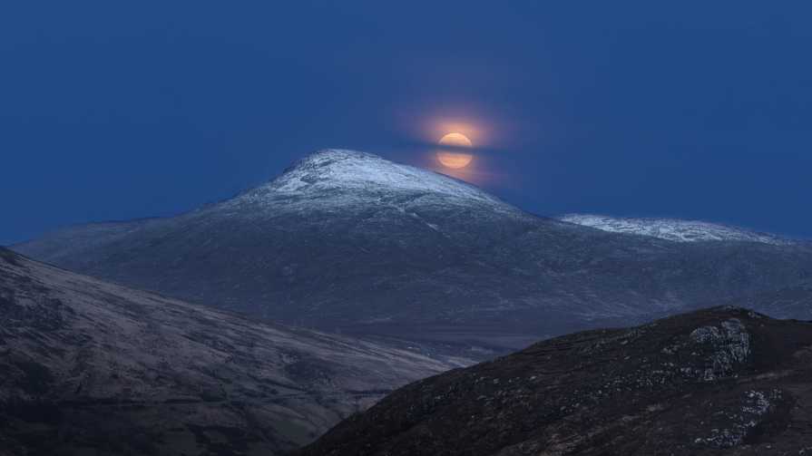
Snow Moon rise over Aghla More, Donegal
The full moon in February is called a Snow Moon. This year the Snow Moon occurred when the moon is at the apogee of it's orbit (furthest from Earth). This photo was captured rising above Aghla More on when descending from the Derryveaghs. Aptly the Derryveaghs and Aghlas were mantled in snow. |
||
| simon3 2024-02-10 06:56:21 |
MountainViews Gathering - 1st March
Hi All - a reminder that the Annual MountainViews Gathering is taking place on March 1st.Date: Friday 1st March 2024 Location: The Talbot Hotel, Stillorgan Road, Co. Dublin, A94 V6K5 Time: 8pm (Doors open 7.30 pm) Panellists, Awards, Talks and a bar for those that are interested in such things! We've created an eventbrite page so that you can purchase tickets in advance - https://mviews2024.eventbrite.ie It would be helpful if you could purchase your ticket in advance so that we can keep an eye on numbers (payment on the night will be possible - although incase we are overrun with the hiking masses, try purchase your ticket in advance). We hope to see you there! Miriam |
||
| miriam 2024-01-28 16:48:13 |
MountainViews Survey - Tell us what you think
A survey has been designed to collate feedback from MountainViews users about the Website and Newsletters. This is your chance to tell the MountainViews Committee what you think - we can then prioritise the work that needs to be done and also hear what you like about the current offering. If you haven't completed the survey yet, we would really value your input! Please copy and paste the link below to tell us what you think:https://rcsiquality.eu.qualtrics.com/jfe/form/SV_5anA2OZFM9yeuEu Many Thanks, Miriam |
||
| miriam 2024-01-28 16:29:53 |
MountainViews Gathering - March 1st
Hi All - a reminder that the Annual MountainViews Gathering is taking place on March 1st.Date: Friday 1st March 2024 Location: The Talbot Hotel, Stillorgan Road, Co. Dublin, A94 V6K5 Time: 8pm (Doors open 7.30 pm) Panellists, Awards, Talks and a bar for those that are interested in such things! We've created an eventbrite page so that you can purchase tickets in advance - https://mviews2024.eventbrite.ie It would be helpful if you could purchase your ticket in advance so that we can keep an eye on numbers (payment on the night will be possible - although incase we are overrun with the hiking masses, try purchase your ticket in advance). We hope to see you there! Miriam |
||
| Geo 2023-11-25 21:13:32 |
Skye Trail - July 2023
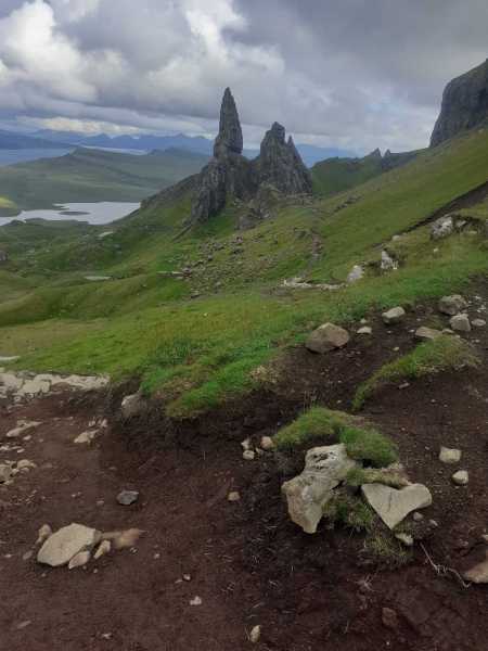
My Skye TrailMost people do the trail from North to South, but I had organised permission to leave my car in the excellent Broadford community campsite on the south of the Isle. Sunday 9am, with fair weather and the sun on my back, I was feeling strong and also had a great feed at Mrs. Mack's burger van on the coast road past the hamlet of Torrin. I made my mind up to keep going, plodding past the foot of the beautiful Bla Bheinn and on to Kilmarie. I took a shorter route over the hills to Camusunary Bay. By now the rain was on me. After 11 hours or so and over 30km of mixed terrain it was time to pitch camp on possibly one of the most beautiful shores I had ever seen. I slept like there was no tomorrow, the sound of the sea swishing through my dreams. Next morning was wet so it was 10am when I broke camp. I had a lonely glen until I reached Sligachan, where I crossed the islandís main road. I pushed on, it was a day of several deep river crossings and my feet were soaked and beginning to hurt. By tea time I reached the cul de sac at the end of Loch Sligachan. Then a horrendous road walk to Portree campsite. 10 pm 30+ km and 12 hours after starting I was putting up my tent in the rain and wondering what the hell I had brought this misery on myself for. Next morning, after some advice I decided to take the bus up to the North of the island and then walk back towards Portree, an unorthodox way of doing the trail but at least I'd finish in civilization! My feet were torn and bloody and I hobbled onto the bus in my crocs with my boots in my hand. I got off at the famous red phone box and sat in the grass trying to medicate my feet then hobbled for the first few kilometres, breaking every hour or so as my left shoulder was now throbbing with the 15kg rucksack. The saving grace was that it was my third day but my first without rain, and I had warm sun on my face. This was a beautiful coastal section, along gorgeous cliffs and on soft turf. I finished by the beautiful lakes at the foot of the atmospheric and Tolkienesque Quaraing, camping on the stony shore of a lake. A relatively short day of less than 20km and only about 6 hours walking. It was a superb wild camp, and sleep was no problem again. Next day, was going to be the beast, another 30km day with nearly 2000m climbing up and down over a half dozen tough hills until I reached the Old Man of Storr. I managed it, but just before my last big climb I got enveloped in the cloud and the rain came back, heavy and ruthless. I was dog-tired and I sat down to ponder. Two lads going in the other direction stopped and asked my advice on continuing over where I had come from. I advised they retreat to lower ground to camp. I felt better so I pushed on, dusk falling as I dragged my sorry self by the Old Man of Storr. There was nowhere to camp so I set up literally on the path's edge, with the last sightseers to the rock pointing at me in my tent and some even taking pictures of the mad Irishman camping on a trail to the island's busiest beauty spot! Poor sleep, I got up at 5am and although it was only about a 15km, 500m ascent day, I was in poor shape. The first few kms my feet had ultra pins and needles and I thought they would give way, but when I reached moorland it was easier. I had a couple of hills to negotiate but my mind was set on my finish in Portree. I met a couple from Wales who I walked the last section with. To be honest, although I was happy walking on my own the previous 4 days, having human interaction again at this point got me through those last few hours. It was an anticlimactic feeling finishing. I was too tired to enjoy it, all I could imagine was a hot shower and the drive back home the next day. But in hindsight it was an incredible experience, 130km in 4 and a half days, superb scenery, marred somewhat by the awful rain but, still, for me a great achievement. |
||
| Colin Murphy 2023-09-19 15:16:03 |
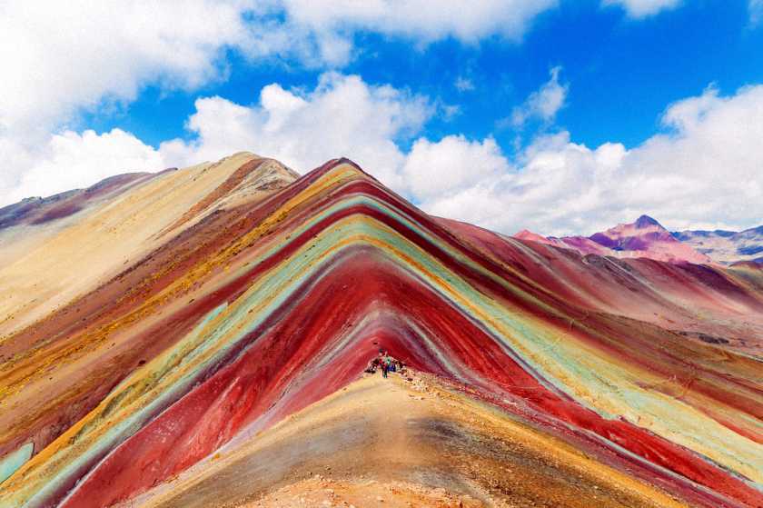
At the end of the rainbow...
We all know the devastating effects of climate change, but in extremely rare cases, it can result in something that might be viewed as positive. One such case is to be found in Peru, and the amazing phenomenon of Rainbow Mountain (5,200m), 1000km SE of Lima in the Andes. Up until as recently as 2013, it was permanently covered in snow and ice, but due to rising temperatures, the mountainís beauty has been revealed. The colours are a result of 14 different mineral compositions, among them quartz, sandstone, iron, magnesium & sulphur. Nowadays snowfall is restricted to the winter months (June-August) and even then, the mountain is only partially covered. It is possible to climb the mountain, but only in the company of a group and a local guide. The actual ascent takes about 3-4 hours. Photo credit: Michaellbrawn |
||
| Colin Murphy 2023-09-19 11:37:10 |
A hillwalking opportunity next to Zurich
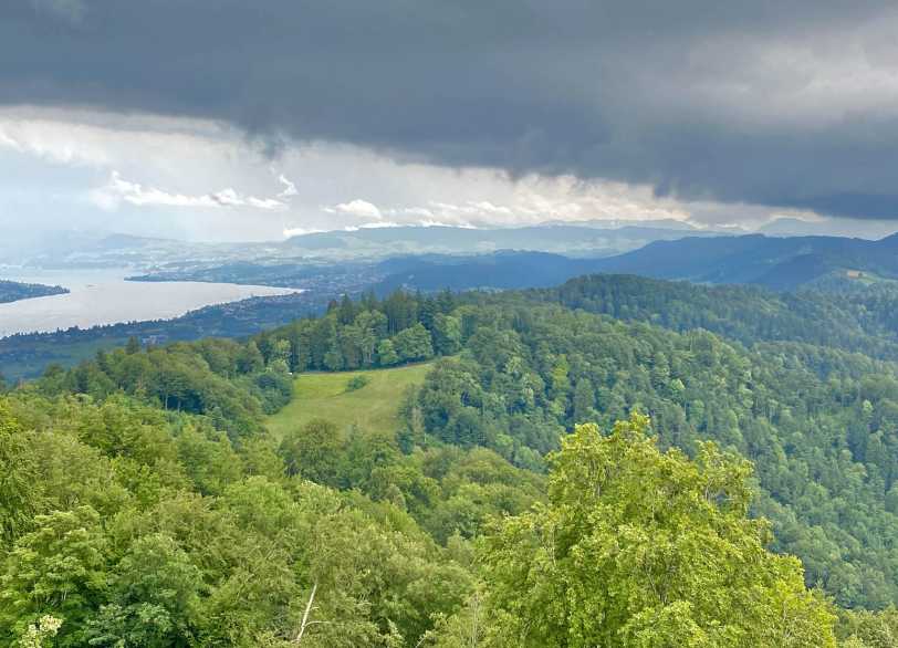
Anyone visiting Zurich who might fancy adding a short hillwalk to the their stay, might consider bagging a very mirror ĎAlpí called Uetliberg, which provides great views over the city, the Zurichsee Lake and the surrounding mountains. Itís a popular day trip for visitors as you can catch a train in central Zurich to Uetliberg Station, which leaves you just a 1km hike up through a forested hillside to the summit (451m). There is a bar/restaurant there to slake your thirst and multiple viewing points. You will also have the option of doing one of the multiple longer treks through the nearby forested hills. |
||
| Djouce 2023-09-09 11:59:47 |
Sunglasses Hungry Hill
I know this is a very long shot but I lost a pair of prescription sunglasses in a grey case on Hungry Hill in August 2023. If anyone finds them please let me know. Thanks. Niall |
||
| Djouce 2023-09-09 11:57:47 |
Hungry Hill
I would be interested to know the origin of the (English Language) name 'Hungry Hill' in the Caha mountains. Is it connected to the famine? |
RECENT CONTRIBUTIONS 1 2 3 4 5 .. 12 Next page >>
|
|
|
||||||||
|
|
|
||||||||
|
|
|
||||||||
|
|
|
RECENT CONTRIBUTIONS 1 2 3 4 5 .. 12 Next page >>
